Thursday, March 31, 2011

Japan quake affects global production of iodine and other minerals


25% of the world's iodine production comes from plants in Japan affected by the March 11 earthquake and tsunami.

A new report by the U.S. Geological Survey indicates that the affected area"is home to nine cement plants, eight iodine plants, four iron and steel plants, four limestone mines, three copper refineries, two gold refineries, two lead refineries, two zinc refineries, one titanium dioxide plant, and one titanium sponge processing facility [right]. These facilities have the capacity to produce the following percentages of the world’s nonfuel mineral production: 25 percent of iodine, 10 percent of titanium sponge (metal), 3 percent of refined zinc, 2.5 percent of refined copper, and 1.4 percent of steel. In addition, the nine cement plants contribute about one-third of Japan’s cement annual production."

The iodine and titanium production loss could have global impacts, but the loss of cement production could hinder Japan's efforts to rebuild it's damaged or destroyed infrastructure of roads, bridges, ports, and buildings.


Ref: Menzie, W.D., Baker, M.S., Bleiwas, D.I., and Kuo, Chin, 2011, Mines and mineral processing facilities in the vicinity of the March 11, 2011, earthquake in northern Honshu, Japan: U.S. Geological Survey Open-File Report 2011–1069, 7 p. (Available only at http://pubs.usgs.gov/of/2011/1069/.)
UA Geology grad program #1 in U.S.


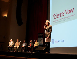
The University of Arizona graduate program in Geology is tied for #1 in the U.S. with the University of Michigan, in the new rankings by U.S. News & World Report. [right, UA Dean of Science and Geosciences professor Joaquin Ruiz moderates the forum on the aftermath of the Japan earthquake on March 29. At right on the panel is UA Geosciences seismology prof Susan Beck. Credit, UA]

UA comes in #10 in Geochemistry, and tied with Brown at #14 in Geophysics & Seismology, for a cumulative Earth Sciences ranking of #7.

ASU is ##17 in Geology and 16 in Geochemistry, for a combined ranking of #17.

Wednesday, March 30, 2011

GeoDaze offer 70 presentations at UA


GeoDaze 2011, the 39th Annual Geosciences Symposium gets underway on March 31, with 70 technical presentations over two days. The event is organized by Geoscience Dept. grad students with financial support from a variety of private donors.

In addition, to an incredible scientific program, they are hosting Jorge Cham, creator of PhD Comics, one of my favorites.

On Saturday, AZGS's Charles Ferguson, is leading a field trip to the Santa Rita Mountains "to examine and discuss new mapping near the Sawmill Canyon fault zone. This prominent strike-slip feature is thought to consist of two fault strands separated by a 1-3km wide septum of strongly folded Mesozoic sedimentary rocks. Charles is going to propose that one of the fault strands is actually a buttress unconformity, which has major implications for the age of many rocks in the Santa Rita Mountains and Mesozoic-Tertiary tectonics in SE Arizona."

Impacts of Japan quake roll across Arizona


It was standing room only at the Arizona Corporation Commission special hearing in Phoenix yesterday on safety of Palo Verde Nuclear Generating Station [right, credit APS], in light of the reactor disaster in Japan.

At the same time, 1500 showed up at the University of Arizona for a forum by experts on a range of quake related topics.

The ACC hearing room drew a phalanx of power plant officials, at least some opponents of nuclear power, and a bevy of reporters - tv, radio, and print.

AZGS has not testified before the ACC in a long time, so I was asked to provide a brief explanation of our role in natural hazards, including the statewide broadband seismic network we've been operating for the past 3 years.

It was on the drive home to Tucson, listening to the news, that I realized this was the first public hearing in the U.S. on nuclear plant safety since the Japan quake, which helps explain not only the local interest but the national attention being paid to it.

Palo Verde was described as having the 18th highest risk in the U.S. from earthquakes by MSNBC, but the Nuclear Regulatory Commission came out last week disavowing the entire report. An NRC spokeswoman, Lara Uselding, is quoted, “It was an incomplete report on the overall research that had been done by the NRC. Somebody at MSNBC took numbers and threw them together to create the rankings. We have said that is not accurate because the NRC does not rank plants by seismic risk.”

Tuesday, March 29, 2011

Northern Arizona uranium EIS public comment period extended 30 days


We heard from BLM this afternoon that the agency is officially extending the public comment period on the northern Arizona uranium EIS by 30 days until May 4. We had been hearing from people trying to wade through the vast amount of materials that they wanted more time, but it sounds like one or more of our Congressional reps also called for it.

This will undoubtedly push back the time line for the decision on the final EIS. The Interior Dept. segregation order for nearly 1 million acres of federal lands from mineral exploration and development, expires on July 21.

Monday, March 28, 2011

Hearing on Palo Verde safety


The Arizona Corporation Commission is holding a public hearing on safety of the Palo Verde Nuclear Generating Station on Tuesday afternoon in Phoenix in response to all the angst over the Japanese reactor problems. I'm on the agenda to provide background on active faulting, historical seismicity, current earthquake monitoring, and earth fissure hazards.

AZGS has been involved in Palo Verde siting and safety since at least the mid-1970's. Our Field Notes story from 1976 [right, available online] describes the site characterization and excavation prior to the first unit going up in 1982.

The 7-page report refers to the 1887 Sonora earthquake as a magnitude 8 event occurring about 250 miles from the plant location, so that a similar sized event was planned for on the nearest known fault, about 72 miles away. Ironically, the 1887 Sonora quake was subsequently determined to have been in the 7 - 7.5 magnitude range, meaning the plant may have been designed for a larger event than was expected.

Another land deal in Holbrook potash play


Passport Potash appears to have a deal for almost 16,000 acres of mineral rights in Arizona's Holbrook basin to add to one of two largest holdings in the potash play. A press release this afternoon says Ringbolt Ventures has optioned their land position to Passport in exchange for cash, a 3-year exploration commitment, and a royalty on future production.

Passport announced a partnership with the Hopi Nation a couple weeks ago for their fee lands at the south end of the potash area. Passport and the HNZ joint venture each have large land positions are both currently drilling core holes.

Chino Valley seismicity


Last week's M3.7 earthquake in the Clarkdale area prompted NAU's Lisa Linville to look at recent and historical seismicity in the Chino Valley region in more detail. If you aren't reading her "Groundswell" blog, this is a good reason to check it out.

Lisa says there is no easily identifiable 'culprit' fault to explain recent earthquakes.

UA public forum on Disaster in Japan


The unfolding drama in Japan continues to grip our attention with continuing reports of trace amounts of radiation being detected from the Fukushima reactors. The University of Arizona is holding a public forum Tuesday evening a6 6:30 pm at Centennial Hall on the UA campus, with a panel "to provide expert perspectives on the science behind the earthquake, tsunami and nuclear crises that have engulfed Japan."

Panelists include:

* Susan Beck, UA professor of geosciences

Beck will provide an overview of the earthquakes and tsunamis that are at the core of Japan's catastrophe. Her research involves using broadband seismology to understand mountain belts, earthquakes and faulting. Current studies include earthquakes and Earth structure associated with subduction zones and strike-slip plate boundaries.

* Eric Betterton, UA professor and head of atmospheric sciences

Betterton will describe the transport of radioactive particles in the atmosphere and the possible consequences for the western U.S. Betterton's research focuses on atmospheric and environmental chemistry, including aerosols, cloud condensation nuclei, frozen solution chemistry, microphysical and chemical properties of winter precipitation, urban air quality, and groundwater remediation.

* Paul Bonavia, chairman, president and CEO, UniSource Energy Corp.

Bonavia will examine the unfolding consequences of this disaster on energy policies worldwide. Prior to joining UniSource Energy in 2009, Bonavia served as Presidents of the Utilities Group and Commercial Enterprises at Xcel Energy. Bonavia serves on the Dean's Board of Advisors of the UA College of Science.

* Dr. Baldassarre Stea, UA professor and head of radiation oncology

Stea will provide an understanding of the effects of radiation on human health. Stea is board-certified in radiation oncology and treats patients with lung cancers, melanoma, brain tumors and pediatric cancers.

* John Williams, UA professor of nuclear and energy engineering

Williams will provide an insider's perspective on the challenges presented by the nuclear reactor technology. As director of the UA Reactor Lab, Williams coordinated the recent decommissioning of the University of Arizona's 52-year old TRIGA nuclear reactor.

[adapted from the UA press release]

Saturday, March 26, 2011

Alternative uses pushing copper demand


Antibacterial copper in hospitals, electric cars, and wind turbines are just a few of the new demands for copper that is helping drive global demand, according to both Codelco, the world's largest copper producer, and Freeport McMoRan, the largest copper company, in separate reports on Mineweb.com. [photo credit, Freeport McMoRan]


Richard Adkerson, president and CEO of Freeport is reported to have told the Reuters Global Mining and Steel Summit that their order books are full indicating the economy is coming out of the recession, despite continued week construction demand.


Friday, March 25, 2011

Making sense about science


Sense About Science is an independent UK charitable trust that responds to "the misrepresentation of science and scientific evidence on issues that matter to society, from scares about plastic bottles, fluoride and the MMR vaccine to controversies about genetic modification, stem cell research and radiation." The group brings scientists together with reporters to respond to news stories and public claims.

I'm at the COPUS board meeting in Berkeley where we are getting a briefing this morning by Dr. Leonor Sierra, Science and Policy Manager for Sense About Science, who is describing how the program works and the challenges scientists face, not only in the UK, but worldwide.

The group has a wonderful set of short easy to read reports on the above topics as well as background reports on how science is done including "I Don't Know What to Believe," that explains the peer review process. All the reports are free for download. There is a long list of "For the Record" responses to specific news reports.

Leonor is in the U.S. meeting with groups about the potential to collaborate.

Thursday, March 24, 2011

Arizona company sold out of Geiger counters


Prescott-based Mineralab, which operates the Geigercounters.com mail order site, reported last week that they are completely sold out of Geiger counters due to the crisis in Japan, and are not taking any more orders until further notice. They warn customers that it may be weeks to months before all existing orders can be filled.

The company website shows models ranging from $259 pocket models to top of the line versions at $1195. The "Prospector" model at right retails for $979.

AZGS continues to get inquiries about the dangers of radiation from the Fukushima nuclear plants and we are referring people to the Centers for Disease Control web site for detailed information. Everything we've seen shows that the radiation levels detected in the U.S. are comparable to levels we routinely experience from other sources and are well below those that will cause health problems.


Thanks to Larry Fellows for the link.

House Committee asks, "Where is the geology in the USGS?"


How can the Geological Survey in its budget continue to support cuts in the energy and minerals programs while at the same time increasing significantly the budgets for ecosystem restoration and climate change?” That was the opening question of USGS Director Marcia McNutt by Doug Lamborn (R-CO), chairman of the U.S. House Subcommittee on Energy and Mineral Resources,at a hearing on the USGS budget on March 9 as described in a report issued by the American Institute of Physics today.

AIP said "Ranking Member Rush Holt (D-NJ) expressed concern about potential cuts to the national streamgage network and National Cooperative Geologic Mapping Program and the proposed elimination of the National Geological and Geophysical Data Preservation Program, citing the import of these programs to state geologists and local communities who rely on the data provided."

Both of these programs are cooperative efforts with AASG and are priority issues for State Geological Surveys.

"The Interior Appropriations Subcommittee hearing...had a very different tenor. Both Chairman Mike Simpson (R-ID) and Ranking Member Jim Moran (D-VA) expressed great appreciation for the important work carried out by USGS."

The AIP report adds a lot more detail on the hearings.

This is cross posted at State Geologists blog

Tuesday, March 22, 2011

Utah county officials want N. Arizona uranium lands opened


Interesting story in the St. George (UT) Spectrum about a roundtable meeting between Arizona and Utah county officials and the BLM. The focus seems to have been on Interior Dept. Order 3310 that allows BLM to designate 'wild lands' for their naturalness factors. Previously, Congress had to formally create wilderness by law. Wilderness is one of the most passionate land debates in Utah. Yet Order 3310 has not generated much attention in Arizona.

But they also weighed in on the proposed withdrawal of nearly 1 million acres of federal lands in northern Arizona from mineral exploration and development. According to the article, commissioners from Utah's Garfield and Washington counties, along the Arizona border, argued in favor keeping the lands open to mineral entry, predicting billions of dollars in economic development for the two state region over the next 40 years.

BLM is accepting public comment on the draft EIS through April 4. The temporary 'segregation' of the million acres ends in July.

Arizona meteorite hunters released from Omani arrest


I got home tonight just in time to catch a story on Tucson's KVOA channel 4 about two Arizona meteorite hunters, Michael Farmer and Robert Ward, who were arrested in Oman for illegal 'mining' and each held "25 days in an interrogation center in an 8 foot by 8 foot cement cell with a blanket on the floor" before being sentenced to 6 months in prison. A legal appeal and help from the US Embassy got them released last week, just before civil unrest started rippling through that Mideast nation. You can watch the video interview online.

National Phenology Network - taking the pulse of the planet


How many of us know that we have a National Phenology Network or that is it headquartered here in Tucson?

The NPN web site informs us that "Phenology refers to recurring plant and animal life cycle stages, or phenophases, such as leafing and flowering, maturation of agricultural plants, emergence of insects, and migration of birds."

The USGS has published a new fact sheet on the NPN:
"The Network is a consortium of organizations and individuals that collect, share, and use phenology data, models, and related information to enable scientists, resource managers, and the public to adapt in response to changing climates and environments. In addition, the Network encourages people of all ages and backgrounds to observe and record phenology as a way to discover and explore the nature and pace of our dynamic world"

Actually, we know the NPN well, with one of our former staff members coming from the program and ongoing discussions about sharing data integration techniques.

Monday, March 21, 2011

Arizona lags New Jersey in solar power


The Solar Energy Industries Association reports that 2010 was "a banner year...with the industry’s total market value growing 67 percent from $3.6 billion in 2009 to $6.0 billion."

SEIA says "In total, 878 megawatts (MW) of photovoltaic (PV) capacity and 78 MW of concentrating solar power (CSP) were installed in the U.S. in 2010."

However, when you look at what states are solar 'hot spots', you see California not unexpectedly leading the pack with 27% of the installed capacity and Florida at 12%. But coming in at #2 with 14% is New Jersey. New Jersey?!?! What's going on there? And Pennsylvania at 5%. Not your stereotypical sunbelt states.

Arizona, Nevada, and Colorado are all tied with 6%. Seems like we have room to grow, given our 350 days of sunshine per year. [right, installed solar capacity. Credit SEIA]

Sunday, March 20, 2011

ASU releases thousands of new lunar images


The Arizona State University team led by professor Mark Robinson, released a huge volume of new images from the Lunar Reconnaissance Orbiter Camera (LROC) that were acquired between September 16, 2010 and December 15, 2010.

The release includes 69,528 electronic images totaling 17,651 gigabytes worth of data. [right, LROC mosaic centered on Orientale basin. The distance from corner to corner is about 4,000 km. Credit, NASA/GSFC/Arizona State University]

A lunar crater Easter egg


It looks like a tie-dyed Easter egg, but the Lunar Reconnaissance Orbiter Camera (LROC) image of the day for March 14 is of Linne crater.

"Color coded shaded relief map of Linné crater (2.2 km diameter) created from an LROC NAC stereo topographic model. The colors represent elevations; cool colors are lowest and hot colors are highest [NASA/GSFC/Arizona State University]."

The Taming of the Salt


There's a lot written in the past week to mark the 100th anniversary on March 18 of the dedication of the Roosevelt Dam on the Salt River east of Phoenix, and the impact of the dam on Phoenix and Arizona. I particularly enjoyed Tom Beal's piece in the Arizona Star. [right, Teddy Roosevelt at the dedication. Credit, Walter Lubken, US Reclamation Service]

The dam provided the water that supported agricultural irrigation and population growth of the Phoenix valley, now accounting for close to 2/3 of Arizona's population. The dam tamed the fluctuating Salt River, bringing stability for that growth.

Even today, with Colorado River water in the Central Arizona Project and extensive groundwater pumping, Tom notes that "With additions completed in 1996, the reservoir behind Roosevelt Dam can now hold nearly 1.7 million acre-feet of water, about two-thirds of the Salt River Project's surface water storage."

A year after the stability engendered in part by this massive federal investment, Arizona became a state.

So, a question comes to mind - would we build Roosevelt Dam today if we had to do it over again?

As one of the baby boomer generation, I came of age in a time that viewed 'other' environments as something that had to be tamed and brought into production. Deserts had to be made to bloom, had to be turned into farmland, rather than appreciated for their own value and role in the ecosystem. (and 'ecosystem' was a word we wouldn't hear in the lexicon for many a year).

It's appropriate that 100 years after beginning the Roosevelt Dam, we are again having an intense debate over our future and its dependency on water. What decisions will we make today and will their impacts be equally important a century from now?

Openings on Arizona BLM's Resource Advisory Council


The BLM announcement is reprinted here in most of it's entirety:

The Bureau of Land Management in Arizona announced today that it is seeking public nominations for five open positions on its Resource Advisory Council, which advises the BLM on public land issues. The BLM will consider the nominations for 45 days after today, when the agency is publishing its formal call for nominations in the Federal Register.

The BLM’s Resource Advisory Councils (RACs), composed of citizens chosen for their expertise in natural resource issues, help the Bureau carry out its stewardship of 245 million acres of public lands. The Bureau, which manages more land than any other Federal agency, has 28 RACs across the West, where most BLM-managed land is located. Each RAC consists of 12 to 15 members with an interest in public land management, including such individuals as conservationists, ranchers, outdoor recreationists, state and local government officials, Tribal officials, and academics. The diverse membership of each RAC is aimed at achieving a balanced outlook that the BLM needs for its mission, which is to manage the public lands for multiple uses.

Individuals may nominate themselves or others to serve on an advisory council. Nominees, who must be residents of the state or states where the RAC has jurisdiction, will be judged on the basis of their training, education, and knowledge of the council’s geographical area. Nominees should also demonstrate a commitment to consensus building and collaborative decisionmaking. All nominations must be accompanied by letters of reference from any represented interests or organizations; a completed background information nomination form; and any other information that speaks to the nominee's qualifications.

The five RAC positions open in Arizona are in the following category/ies:

Category One – Public land ranchers and representatives of organizations associated with energy and mineral development, the timber industry, transportation or rights-of-way, off-highway vehicle use, and commercial recreation. (One Position Open)

Category Two – Representatives of nationally or regionally recognized environmental organizations, archaeological and historical organizations, dispersed recreation activities, and wild horse and burro organizations. (Two Positions Open)

Category Three – Representatives of state, county, or local elected office; representatives and employees of a state agency responsible for the management of natural resources; representatives of Indian Tribes within or adjacent to the area for which the RAC is organized; representatives and employees of academic institutions who are involved in natural sciences; and the public-at-large. (Two Positions Open)

Nominations should be sent by April 30, 2011, to Dorothea Boothe, Bureau of Land Management, Arizona State Office, Communications Division, One N. Central Ave., Suite 800, Phoenix, Arizona 85004. For additional information, contact Dorothea Boothe at (602) 417-9504. The Nomination Form can be found at: http://www.blm.gov/style/medialib/blm/az/pdfs/rac.Par.2014.File.dat/2011-Nomation-Form.doc

Potash coring results released


Passport Potash has posted a new presentation about their work on the Holbrook basin potash deposit, including a map of their land holdings and results from their first core drilling [right, credit Passport Potash]. The company reports KCl values of 11.17% to 23.42% in prospective intervals. These look generally comparable to figures reported by Arkla in the 1960's.

Goodinfo's Blog "About Nothing" has been covering Passport extensively and he passed along links to two photo sets from last week's company tour of the exploration site.

Goodinfo, who is also an investor in Passport, argues that a mine in Arizona can be put into production in 3-5 years for $750 million to $1 billion, compared to 10 years and $5-12 billion in capitalization for a Canadian mine. If those numbers hold up, that will be a significant advantage for Arizona's deposit to be developed.

Saturday, March 19, 2011

Mineral museum protest at state capitol


A group showed up at the Arizona State Capitol in Phoenix last Tuesday to protest about the conversion of the Arizona Mining & Mineral Museum to a new "Arizona Experience" center as part of the state's 2012 Centennial. But last week was also Spring Break for many and the Capitol mall was protest central for everyone with an issue. I was there on Wednesday and saw individuals and groups with signs, stilts, costumes, petitions, bullhorns, and flags, covering Medicare, immigration, health care, taxes, recalls, and some issues I never did figure out.

The Mineral Museum group did get brief recognition in an Arizona Republic story about all the protesting. The picture at right is from Dick Zimmerman's "Mineral Museum Madness" blog which advocates maintaining a museum dedicated to mining and minerals.

Solar manufacturing plant announced in Mesa


Tempe-based First Solar announced plans to build a new manufacturing plant for photovoltaic (PV) solar modules in Mesa. The plant will build modules capable of producing 250 megwatts of electricity per year and employ 600 workers.

The company says the facility is located on a 135-acre site that was previously home to a General Motors vehicle testing facility and is designed to accommodate future expansion. Construction is set to begin in 2Q 2011 with delivery of solar modules in 3Q 2012.

First Solar is a world leader in thin-film technologies that have brought down solar panel prices dramatically in the past few years. They use cadmium-tellurium (CdTe) modules [right, credit First Solar] rather than the more common polycrystalline silicon panels.

Company expects Holbrook potash mining in 5 years


Passport Potash company president Joshua Bleak expects to start construction of a potash mine in the Holbrook basin in 3 years with actual mining to begin in 5 years, according to a story in the Arizona Journal. Bleak and other company personnel spoke to a group of about 100 local government and business leaders and company investors at a luncheon set up at the potash exploration site on Monday. [right, potash sample. Credit, USGS]

According to the news article the company is considering either underground or solution mining options. Solution mining would require about 2,000 gallons of water per minute. The project "has the potential for 1,000 to 1,500 construction jobs, and 300 to 500 full-time jobs that will provide an annual salary of around $70,000," according to Bleak.

Passport and the other company active in the area, HNZ LLC, are each in the midst of extensive drilling and exploration programs in the basin.

Imbalances in geoscience workforce


The latest workforce report from the American Geological Institute demonstrates a 'growing imbalance in the age of geoscientists in the profession" with the majority of geoscientists within 15 years of retirement age, and an aging federal workforce. The has also been an increase at both ends of the faculty pipeline with "a concurrent decrease in the number of full professors."

Within the geosciences, 78% of Mining Engineers in federal government are over 50 years old, the highest percentage of any of the fields. It wouldn't surprise me to see a similar demographic in industry.

Mining law changes face hurdles


An analysis of the politics affecting hardrock mining in the New York Times suggests that western lawmakers and the Republican-controlled House will prevent changes to the hardrock mining laws from being considered by Congress this session. [right, Morenci copper mine, AZ. My photo, 2008]

Mining opponents want to do away with patenting of claims, give recreation higher priority over mining and impose royalties on production. The President's budget proposal calls for royalties, saying "Just as the coal industry is held responsible for the actions of its predecessors, the Administration proposes to hold the hardrock mining industry responsible for abandoned hardrock mines."

Mining proponents argue that U.S. mining has declined and the country is increasingly reliant on imported minerals, such as rare earths.

Utah Geological Survey seeking proposals for geologic research


The Utah Geological Survey is issuing a solicitation for geologic research proposals in the area of "Characterization of Utah's Hydrocarbon Reservoirs, Metals, and Industrial Minerals." They expect to award up to 8 grants, at a maximum of $25,000 per grant, for the Fiscal Year July 1, 2011 through June 30, 2012. Proposals are due May 27.

A list of previous and current projects is posted on the UGS web site. [right, coalbed methane well, Castlegate field, Utah. Credit, UGS]

Uranium Fuel Cycle conference - focus on small reactors


Between the northern Arizona uranium mining EIS and the global impacts of the Japan reactor problems, my inbox is stacked with uranium news. Peter Scholle passed along an announcement for the Uranium Fuel Cycle Conference in Hobbs, NM, April 27-28, that will focus on will focus on "potential developments and implementation of small-scale reactors."

The conference web site talks about small reactors as having capacity to provide "125 megawatts to 750 megawatts of electricity for a five-year operating cycle without refueling." This compares to gigawatt size reactors at full scale plants.

The “Uranium Fuel Cycle” conference will begin with a panel on “Uranium Mining Today: Geology and New Technology,” led by Dr. Peter Scholle of New Mexico Tech. Scholle is the State Geologist and the director of the N.M. Bureau of Geology. The conference will present improved methods for the mining of uranium. New technology that eliminates labor-intensive, high-risk activity prevalent in previous operations will be presented. Also, Uranium Resources Inc., a mining-company based in Texas, will present information about the latest technological developments in uranium mining. The company has several mines in Texas and has holdings in New Mexico that include 183,000 acres and 100 million pounds of in-place mineralized uranium holdings, according to the company’s website.

Also on the schedule for the conference is a panel discussion on uranium processing, featuring top executives from Urenco USA (uranium enrichment), International Isotopes (uranium tailing recovery), Waste Control Specialist LLC and WIPP (waste/storage).

Uranium mining opponents staging Flagstaff concert


Opponents of uranium mining are holding a benefit concert in Flagstaff next weekend as part of the high-profile campaign to influence the Interior Dept decision on withdrawal of 1 million acres of northern Arizona from mineral exploration and development.

The public comment period on the draft EIS continues through April 4. The BLM comment form is available online as part of the EIS fact sheet.

Uranium EIS materials posted online


The public meetings over the proposed withdrawal of 1 million acres of federal land in northern Arizona from mineral entry are over. BLM has posted all the information provided as handouts or posters, including slide presentations at their web site. Chris Horyza at BLM tells us the presentation was video-taped and posted to YouTube and is linked on this same web page. He says that besides the whole EIS packet, other information, including the Socio-Economic Report and the Cultural Class I Overview are posted.

Public comments are being accepted through April 4.

Friday, March 18, 2011

M3.7 earthquake felt across Sedona-Prescott region


A magnitude 3.7 earthquake struck central Arizona just before 1pm local time today north of Cottonwood, about 22 miles west of Sedona, and 26 miles northeast of Prescott. There are reports of weak to light ground shaking reported being felt from across the region and as far away as Phoenix. [right, epicenter shown by orange star, with historical seismicity shown by dots. Credit, USGS]

Potash agreement with Hopi Tribe


Passport Potash announced an agreement earlier this week with the Hopi Tribe for access to privately owned Hopi lands, although not reservation lands, east of Holbrook at the south end of the deposit, for exploration of the potash resource in the basin. The Tribe in turn will have access to the company's exploration results.

New ADEQ director talks about mining, groundwater, climate change


An interview with Henry Darwin, the recently appointed director of the Arizona Dept. of Environmental Quality, is published in the Willcox Range News. Henry is quoted saying, "I think our highest overall priority is preparing ADEQ for the practical reality of economic growth. Mining, in particular, has turned around and they are talking about expansion. We need to be able to prevent long term environmental harm by being prepared to issue permits and do inspections and not just rubber stamp permits. We're not an impediment to growth but we need to use our resources and expertise for environmental protection."

In response to a question about contaminants discharged into dry washes getting into the groundwater, he said,
"our strongest tool to protect Arizona groundwater where there is no surface water is our Aquifer Protection Permit (APP) program that we've applied since the mid-1980s"

He also described climate change, as "a very important issue that shouldn't be regulated through the existing Clean Air Act, but in Congress. I do think there is a need to do something quickly and I'm not suggesting we should wait years. I think Arizona may be poised to benefit from greenhouse gas reductions as we focus on renewable energy development in the state."

There's more in the full interview.

Thursday, March 17, 2011

Senate approves consolidation of Mines & Mineral Resources department with AZGS


The Arizona State Senate approved their FY12 budget yesterday and separately approved the consolidation of the Arizona Dept. of Mines & Mineral Resources with AZGS.

These now go to the House for their action. There are big differences between the Senate budget and the Governor's but not regarding the AZGS budget. Both budgets propose transferring $100K from what would have been ADMMR's FY12 budget, to use to scan and digitize their mining files and put them online for free downloading.

SB1615 is the agency consolidation bill and includes moving ADMMR's mission statement, authorizing language, and confidentiality provision into the AZGS statutes. I've been working with Legislative staff for the past two weeks in crafting this to avoid duplication, and eliminate possible contradictory provisions.

So, while there are still big budget battles to resolve in the state, it appears all parties are pretty much in agreement on the AZGS budget and the consolidation.

In late January, ADMMR ran out of money and shut down. AZGS took temporary custody of their facilities and files and hired most of the staff. The office is now operating as the Phoenix branch of the AZGS and continues to provide the core services and access to files as before.

Tuesday, March 15, 2011

Arizona Senate budget plan


The Arizona State Senate released it's FY12 budget proposal late this afternoon. The Senate may vote on it as quickly as tomorrow (Wednesday).

A few quick geo-related items in the Senate plan -
  • it supports the Governor's plan to consolidate the Dept. of Mines & Mineral Resources with AZGS and transfer $100K to AZGS to digitize mining and mineral resource files; $126K would go to the Historical Society which took over the Mines & Mineral Resources Museum last year
  • the Dept. of Water Resources would replace $795K of state funds with new cities fees
  • it appears that over $15 million will be 'swept' from a dozen programs in the Dept. of Environmental Quality and transferred to the General Fund

First compilation of Pinal County earth fissures complete


The first county-wide compilation of earth fissures in Pinal County is now complete. Maps of the final three earth fissure study areas -- Sacaton Butte, Santa Rosa Wash, and White Horse Pass -- are available online at the Earth Fissure Viewer. The comprehensive Pinal County Earth Fissure Map (1:250,000 map scale) showing all mapped and reported earth fissures in the county is available in PDF format.

Over the past three years, Arizona Geological Survey geologists mapped 86 miles of continuous and discontinuous earth fissures in Pinal County. An additional 167 miles of reported fissures were visited and examined but remain unconfirmed either because recent agricultural or construction activities masked their appearance or because they lack some of the physical attributes used to identify earth fissures.

Nearly 43 miles (50%) of all mapped fissures are exposed on the east side of the Picacho Basin, adjacent to the Picacho Mountains and Picacho Peak. The three newly mapped study areas yielded 5.62 miles of earth fissures, with Santa Rosa Wash accounting for nearly three miles of that. An additional 7.7 miles of previously reported fissures remain unconfirmed.

AZGS monitors growth of existing earth fissures and investigates formation of new ones. As complete the first state-wide compilation of known fissures, we will move into prediction and mitigation phases.

Earth fissure map released for Three Sisters Buttes


AZGS released four new earth fissure area maps today - one in Cochise County and three in Pinal County.

The Three Sisters Butte area in Cochise County [right] covers nearly 19 miles of continuous and discontinuous earth fissures. The fissures are largely bunched in two locales: one group circumnavigating the Three Sisters Buttes, and the second north of Sulphur Hills. In summer 2010, three new earth fissures formed north of Sulphur Hills intersecting and temporarily closing E. Parker Ranch Road.

Larry McBiles, 1956-2011


Word has only circulated widely in the past few days that Dr. James "Larry" McBiles died on March 6. There was a memorial service today in Phoenix. Larry was a prominent educator and particularly well known in mining and geologic circles for his leadership of the Arizona Foundation for Resource Education (AFRE).

His obituary is posted on a number of newspapers around the state with the one at the Arizona Republic has drawn a large number of tributes and remembrances.

His obituary also notes that "Larry transitioned from teacher to district administrator to the position of Deputy Associate Superintendent of the Arizona Department of Education. Following his keen interest in science, Larry next took on the role of Director of Education with the Arizona Mining Association where he received the 2005 Medal of Merit by the American Mining Hall of Fame."

Donations in his memory may be made to the Center for Teacher Success, 141 East Palm Lane, Suite 100, Phoenix, AZ 85004 in support of Larry's lifelong work to provide professional development support and services to educators across the state.

Monday, March 14, 2011

National Geographic showcases ASU lunar image


Dark streaks in the lunar crater Diophantus captured by the ASU-run Lunar Reconnaissance Orbiter (LROC) camera made this the project's featured image of the day and also a selection by National Geographic. ASU provided this description (Feb. 23):
Today's Featured Image reveals the upper slopes of Diophantus crater, located on the western edge of Mare Imbrium. The upper dark area of this image corresponds to the flat mare surface, outside of the crater. The most striking feature here is the dark material that flowed down the crater wall. The reflectance of surface materials is controlled by various factors such as sunlight direction, grain sizes and surface textures, and composition. In this picture, the dark materials are most likely a different composition (relatively bright materials also flowed down-slope next to the dark flows).These dark features originate from several layers exposed in the crater walls. The horizontal extent of these layers is rather discontinuous and they appear at various elevations; their thickness ranges from five to ten meters. What material composes these dark slides? We know from samples returned from the Apollo 17 mission that very dark pyroclastic materials (explosive volcanics) exist on the Moon. Perhaps these slides are a layers of pyroclastics that were buried by younger lava flows. When Diophantus was formed these layers were exposed! There is much to be learned about the distribution and chemistry of pyroclastics and in turn about the deep interior of the Moon. Imagine future astronauts rappelling down to sample these exposures!

Multi-part public radio series on Arizona copper


Tucson's Arizona Public Media launched a multi-part series today titled "Copper at the Crossroads" that examines copper mining in Arizona. Based on their blurb, it appears they take the position that it's a simple debate - jobs vs environment. [right, footprints of existing and proposed copper mines in the greater Tucson region. Brown are the pits, red represents tailings, and yellow are waste rock. The location and sizes at the Rosemont site are postulated.]

Nevada budget woes - more taxes on mining, huge cuts to geological survey


Things are tough in Nevada. State Geologist Jon Price sent out an open letter to stakeholders of the Nevada Bureau of Mines & Geology yesterday calling for support to challenge a proposed 53% budget cut to the agency. I've also posted the full letter at our sister blog, "State Geologists."

Meanwhile, Mineweb.com reports that the Nevada's chief tax collector was forced out after he revealed that his agency has not performed an audit of mining company tax payments in two years. There is a passionate debate in that state over increasing taxes on mining and this news on compliance did not go over well.

Nevada was the #1 mineral producing state in the nation in 2010, with production of $7.55 billion, equal to 11.8% of total U.S. mineral production. [right, reverse of one of the 100 one-ounce gold coins that were struck to commemorate the fifty millionth ounce of gold production from the Carlin trend. Photograph provided by Ronald D. Lewis, Great Western Mint, Orem, Utah.]

Sunday, March 13, 2011

U.S. subduction zone quake - it will happen here


On January 26, 1700, a magnitude 9.0 earthquake occurred along the Cascadia subduction zone off the coast of Oregon and Washington. It generated a tsunami that rolled across the Pacific an hit the Honshu region of Japan the next day, reaching 5 meters in height.

It was a mirror image of the 9.0 Japan quake and tsunami of two days ago.

And it is a geologic certainty that another Cascadia megaquake will strike the Pacific Northwest some time and we now have graphic evidence of what that means.

My colleagues in the Oregon and Washington geological surveys recognize this hazard and are heavily engaged in trying to understand the potential and mitigate the risks. But trying to prepare for an event that may not occur in the lifetimes of those who fund this work is often an uphill battle.

In Japan, they have a warning system that recognizes the P or primary waves of a major quake and sends out emergency warnings that the slower but much more damaging S (secondary) and later surface waves will be coming shortly. Many in Japan had a crucial 30-40 seconds warning. That can be enough time to shut down critical facilities or get to cover. The tsunami warning system gave residents 30-40 minutes in many areas to get to higher ground.

It's long past time to install similar warning systems in seismically vulnerable locations in the U.S.

Update: Geomika offers a review and comparison of West Coast quake hazards at http://www.geomika.com/blog/2011/03/12/tsunami-on-the-west-coast/

Arizona's earthquake hazards

It's a good time to review Arizona's earthquake hazards. Some of the largest historical earthquakes originated outside the state boundaries but the ground shaking did damage in Arizona.

The 1887 magnitude 7.4 quake that originated 40 miles southeast of Douglas, killed 51 in Sonora and did significant damage across southeast Arizona. [top, earthquakes since 1850 in and around Arizona]

The 1940 magnitude 7.1 Imperial Valley event in southern California did serious damage in Yuma.

The Flagstaff area suffered moderate damage from 3 earthquakes in the early 1900's.

Arizona is impacted by shaking from the San Andreas fault system in California, from the Intermountain Seismic Belt that extends south from Utah, and Basin & Range faulting in Sonora, Mexico.

In addition, the San Francisco volcanic field around Flagstaff with 600 volcanoes, has been active for 6 million years with the last eruption less than 1,000 years ago. It is the most seismically active region in the state.

The possible meltdown of nuclear reactors in Japan is prompting questions of the safety of other reactors in seismically active areas. In Arizona, the Palo Verde Nuclear Generating Station sits in the "low" earthquake hazard area, west of Phoenix, just south of the I-10 marker on the map at right. [bottom, earthquake hazard of Arizona based on rates of historical activity, number of potentially active faults, and estimated slip rates for those faults. From the Arizona Geology newsletter, 2000]

Saturday, March 12, 2011

Science and culture festival at ASU


Stephen Hawking, Werner Herzog, Anthony Grayling, Liz Lerman and Jean Auel will be among the celebrities and scientists at Arizona State University April 7-11 for a science and culture festival.

“The festival itself involves music, film and dance as well as other exciting events that involve lectures and panel discussions on topics to be touched on during the festival,” said Lawrence Krauss, founding director of the ASU Origins Project, which is organizing the festival.

The events include Ira Flatow broadcasting NPR's "Science Friday" on April 8 from local station KJZZ, and two documentaries by renowned filmmaker Werner Herzog.

While many of the events are free, others, including a production of Gustav Holst’s masterpiece, “The Planets,” at which Stephen Hawking is scheduled to appear, and the screening of Werner Herzog’s new 3-D movie, are ticketed and have a fee attached.

[take in part from the ASU SESE announcement]


ASU launches lunar farside photo series

ASU kicked off a special series of featured lunar farside images scheduled to be released daily over the next week that were taken by the Lunar Reconnaissance Orbiter Camera (LROC), run by an Arizona State University-based team. [right, LROC mosaic of lunar farside. Credit: NASA/GSFC/Arizona State University]

"The series of images serves as a prelude to next week’s release of NASA's Lunar Reconnaissance Orbiter team’s set of data from the mission's Exploration Phase along with the first measurements from the Science Phase."

"LROC acquires high-resolution images of the lunar surface from a 50-kilometer orbit of any spot on the surface with resolutions down to 50 centimeters/pixel (19.7 inches/pixel) while LRO orbits at a speed of 5,800 km/hr (3,600 miles/hour). The imaging system consists of two Narrow Angle Cameras (NACs) to provide high-resolution images, and a Wide Angle Camera (WAC) to provide 100-meter resolution images in seven color bands over a 57-km swath."

The global mosaic released on Friday is comprised of over 15,000 WAC images acquired between November 2009 and February 2011.

[taken in part from the ASU SESE announcement]

Mary Poulton - the future of mining


An interview with Mary Poulton [right, credit UA], is head of the UA Department of Mining and Geological Engineering and director of the new Lowell Institute for Mineral Resources, explains how her career began with a box of rock.

On December 9, 2010, Mary was officially inducted as a Distinguished Professor, one of the highest honors a UA professor can achieve. Watch the interview at http://www.arizona.edu/features/mining-future